
Silver Lakes - 2015.03.14

Originally posted March 27, 2015
A Tale Of Two Trails...
A friend of ours invited us on an over nighter to Silver Lakes. The plan was to reach the lakes using what I call the Silver Creek Trail. I think the official name is Silver Lakes Way Trail if there is an official name. There is no trailhead sign other than a road marker that has 300 written on it. We had two weeks to watch the weather before heading up the trail. Rain was in the forecast and then snow, back to rain, returning to snow two days before our planned hike. Barking Sasquatch's daughter's had no intention of snow camping so he decided not to go. Me and Deborah were going to go regardless of what the weather. We had a shiny new tent we wanted to test, Deborah needed a reset from work, and I am always eager to backpack.
As it turned out, this would be a hike of two trails - The first day was dry and the second day the trail was under a foot of snow. A perfect example of how quickly events can change in the wilderness, how important it is to be prepared, and to have skills capable of dealing with these changes when they arise. Stories seem endless about someone out for a day hike, gets lost, and either loses their life or need rescuing. Growing up in Alaska I've learned not to take nature for granted, she has a way of teaching us a lesson at the very moment we quit paying attention.


Getting There...
I always enjoy driving forest service roads and FS2860 is one of my favorites. To most it may seem long, especially to "destination" people. However, to us "journey" folk the drive is a scenic wonder. The growing popularity of Royal Basin, Upper Dungeness, and Tubal Cain trails make this a busy road with a lot of tight turns. The road is narrow with plenty of pull outs that very few drivers have the courtesy of using to let oncoming traffic go by. The road is graded in the early spring but doesn't stay smooth for long and you will have plenty of practice in pothole maneuvers. Besides traffic and potholes be on the lookout for large rocks in the road.
FS2860 will take you past the huge parking across a bridge for access to Upper Dungeness, Lower Dungeness, and Royal Basin trails. This will be the last toilet you will see, after this it will be cat-holes and trees. Continue up the road another 8.8km (5.5 mi) and pass the parking lot for Tubal Cain, Gold Creek, and Little Quilcene trails. There is no trail sign, Silver Lakes Way Trail begins at a marker named 300 which is in front of a huge boulder next to a turn in the road. Lots of parking on the right just past the trailhead.
Day One: March 14, 2015
We left our house with thoughts of hiking in either rain or snow so we were quite surprised to find the drive up completely snow free and no rain. The cloud diffused light that reached the forest was the most beautiful I have seen in a long time and made for a lovely beginning to our hike.
Silver Lakes Trail begins at the edge of an old clearcut. As a result you begin in a dog-hair forest which is a result of second-growth trees rapidly growing and choking out all vegetation on the forest floor. It didn't take too long to reach the first crossing of Silver Creek after which we began 4.8km (3mi) climb to Silver Lakes. There has been a lot of trail work and looks used much more than in the past. I remember it looking like a animal trail, now it is a definite footpath with a lot of ribbon in the trees to mark the way.
I can't remember but it seems like there are three plateau's where you will climb very steeply and then level off a bit before reaching the main trail junction to Silver Lakes. At this junction going left will take you to Mt. Townsend, turning right ends at Upper Silver Lake. On the last plateau before the junction there are a few nice camping sites next to the creek. I would probably never camp there with the lakes being so close but it is nice to know they are there and they do make for a pleasant resting place.


Near the trail junction was the first snow we encountered. We lost the trail here for a moment because it had morphed into a creek, appearing to end. After a steep climb out of the ravine we found a ribbon pointing us towards a reroute and it wasn't far at all before we reached the main trail to Silver Lakes.
We made a short stop at a Silver Creek crossing and admired its winsomeness as it flowed through moss-covered rocks and snow. I can sit and listen to the forest here for hours. Another great spot to listen is where the creek exits the Upper Lake, from here sight and sound mingle with the mountain breezes.
Upper Silver Lake is easily one of my favorite locations in the Olympics. It has everything one could ask for backpacking.
Close enough to carry heavy comfort items usually left at home.
Steep enough that most party riff raff won't bother going there.
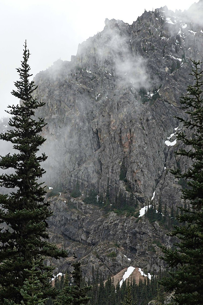
One of the best 360° views of North Cascades and Olympics. Much better than Mt. Townsend I think.
Good trout fishing.
Great place to swim. It even has a nice diving rock.
Lots of bouldering to get you to some amazing views of Quilcene valley, Mt. Buckhorn, Mt. Constance and beyond.
A dogs paradise.
Great trail for beginners transitioning to intermediate.
We arrived at Silver Lakes to find all the campsites under snow with the exception of where I usually camp. It is located on a hill above the upper lake and next to a nice path that takes you to a boulder field above the lower lake.
The lake was frozen, not walkable frozen, except for the edges. Deborah wanted to camp in a different location than our usual place so we walked around the lake and after finding no other campsite free of snow we returned to our usual camp. We had the entire area to ourselves, something that is becoming more and more difficult to experience now that people are visiting the Olympics in greater number. I remember some trailheads like Mt. Townsend where we would be the only car in and out. Now you can barely find a parking place in a newly enlarged lot. This is why I usually access Silver Lakes by the way trail instead of Mt. Townsend now.
Our new Marmot Force 2Ptent went up quick and easy. Deborah and I have a basic system that seems to work great for us.
I find a spot, we decide if it works for both of us, then I pitch the shelter.
Deborah makes the bed and adds the woman's touch to our home.
Meanwhile, I begin cooking dinner and adding finishing touches to camp.
We seldom have campfires. If we decide to, I get that ready and fired up. (no campfires on this trip).
After dinner and watching the evening move in we retired for the night. I must say that I have mixed feelings about the neon green of the Forces rainfly. One thing I am going to like is how softly it lights the inside, even at night. It was much roomier in function than I had thought when I was setting it up in our yard. Though I still think the 38" headroom is a little too low for shelter such as this.
Around 2 AM we heard what we thought was rain tapping on the tent only to realize it was snow. Throughout the night we would wake up and knock the snow off the roof to keep the fly from resting on the mesh walls. Amazingly we had no condensation and remained cozy warm all night. In the same scenario with my single wall shelters Jessica would be wet and shivering from condensation. This time she was warm and dry. I guess the Force 2P is worth the extra 1.14kg (2.5lb) in that feature alone. Have to say that I am very happy with how well the Marmot Force 2P handled its inaugural night.

Jessica Finds a Nice Hiding Place
Day Two: March 15, 2015
Snow was still falling when we woke up in the morning. A measurement revealed about a 30cm (1ft) had fallen and had yet to stop. It was a wonderful sight, as Deborah and I love snow. Winter is easily our favorite time of year and it was almost not existent this year in the Northwest.
The roads can be difficult when it snows like this so we decided to skip breakfast, break camp, and see what it was like at the trailhead. Honestly, I thought it would be raining when we lost elevation but that is not what happened.
About halfway down we stopped to make a breakfast shake under a large cedar that had a snowless patch. It was a peaceful breakfast until the snow on the entire tree decided to avalanche. Wow! I can't believe how much snow a tree holds. It felt like a wind tunnel of snow and when it was over we looked like we had just been hit by a huge snowball. I had taken my coat off at the wrong time. It is my belief that some tree critters started the snow to fall on purpose and are still laughing about it to this day.
The Drive Out...
On our way up the day before there were a lot of cars at the Upper Dungeness and Tubal Cain trailheads. As we went by Tubal Cain we noticed the last car had left just ahead of us. There were still a few cars in the Upper Dungeness lot but there were some hikers hanging out and about to leave. Not too far past the bridge on our way up the hill we had to stop for a truck stuck in the road.
Two guys were throwing anything they could find in the back of the truck so they could get some traction. A VW SUV just ahead of them was abandoned on the side of the road unable to get up the hill.
I had them back down the hill a bit so I could get around then hooked a tow rope to their truck. We pulled them about 9.6km (6mi) until reaching a place they could manage on their own. There were a few stops along the way to let other trucks pass. I talked to a few of the people going by and every one of them mentioned being surprised by the snow, not even realizing there was a possibility of it.
Far too many people go into the wilderness unprepared.


Backpacking Details
Out and Back Distance: 10.78km (6.7mi)
Elevation Gain: 540m (1772ft)
Start Location: Zone 10T; Easting- 493807mE; Northing- 5302361mN
Ending Location: Zone 10T; Easting- 493814mE; Northing- 5302367mN
Custom Correct Map: Buckhorn Wilderness
Longway's Gear List:
Backpacking Gear:
Backpack: Marmot Kompressor Verve 42
Tent: Marmot Force 2P
Sleeping Bag: Marmot Plasma 15
Sleeping Pad: Sea to Summit UltraLight Insulated (small)
Filter: Sawyer Miniw/SmartWater bottle
Shoes: Luna Oso Sandals, Merrell Barefoot
Pants: Mammut
Shirt: Sherpa
Jacket: Mammut
Patagonia Nano Puff Sweater
Repair / First Aid Bag
Compass: Suunto MC-2
Toilet: Boulder Bidet / Sea to Summit Alloy Pocket Trowel
Camera Gear:
Camera: Fujifilm X-T1
Lens: Fujinon 55-200mm
Lens: Fujinon 60mm Macro
Lens: Zeiss 32mm
Lens: Zeiss 12mm
Speedlight: Yongnuo 560lll
Filter: Lee Seven5 .3, .6, .9 GND
Filter: Lee Seven5 Polarizer
Filter: Lee Seven5 Big & Little Stopper (10 & 6 stop) Neutral Density
Release: TriggerTrap& iPhone 5s
Tripod: Gitzo GT2543L
Head: Really Right Stuff BH25
Extras Bag: Batteries, Sensor Cleaning, Off Camera Flash Sensors, etc
Lady On An Isle's Gear List:
Backpack: Deuter ACT LIte 60+10
Sleeping Bag: Marmot Plasma 15
Sleeping Pad: Sea to Summit UltraLight Insulated (small)
Sleeping Pad: Cascade Designs Z Restcut for Jessica
Water Filter: Sawyer Miniw/SmartWater bottle
Shoes: Luna Leadville Trail, Merrell Mix Master Move
Pants: REI Sahara Convertible
Shirt: Sport Hill Dash
Jacket: Columbia Thermalistic
Compass: Suunto MC-2
Repair / First Aid Bag
Bear Vault: BV450w/food